

A Memoir of Redcar - by Fr Neil McNicholas
Lakes Estate - Buttermere Road
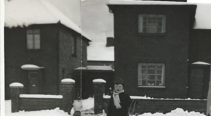
By the time I was about two, after living in two or three flats in Redcar, my parents had moved to temporary housing in one of the Nissen huts of the small ex-Army Biddy Camp on the eastern edge of Redcar where the rugby club and sewage treatment plant are today. But in 1952 we were assigned a brand new council house on the Lakes Estate, one of the early, if not the first, post-war housing projects in Redcar and notable for its pink concrete roads and blue street-lighting.

The house was in Buttermere Road on the very edge of the estate beyond which were "miles" of fields - or so it seemed to a child. Ours, No.7, was amongst the first few houses in the street to be completed and I believe we were the first family to move in because I can distinctly remember sitting chatting with builders during their tea breaks, sharing a biscuit or a sandwich, because there were no other kids to play with. Buttermere Road only had eighteen houses in total, and four in Haweswater Road. When the street was in its heyday, I’d say there were about a dozen of us kids who played together fairly consistently, later becoming a “gang” of about eight or nine lads and two or three girls who we allowed to join – but only because they could fight as well as the boys!
Just trying to recall who lived where at the time: No1 Davis (Emmy and an older brother); No3 Halls; No5 Crossleys (granddaughter Lynn Thomas); No9 Coopers (Heather) and later Browns (Kenneth and Graeme/Graham who died in a road accident); No11 Mitchells (Alan); No13 Smiths (Martin and Linda); No15 Cooperthwaites (twins Ronald & Brian & a younger brother); No17 ?Twaites and later a family with a son called ?Stephen). No2 Glarveys; No4 O’Dells (Margaret & Anne); No6 Gills (Janet and Ilona); No8 Bairds (Alex & Angela); No10 Boltons (Brian & Carol); No14 Piercys. And in Haweswater: on one side Pearsons (Ronnie, David & Michael) and Arthurs; and on the other side Carrs and Holmes (Veronica and Celia).
‘United’ (remember the old red buses?) used to provide a regular double-decker service to and from the town. The bus came up West Dyke Road to its junction with Troutbeck Road (that’s as far as West Dyke Road went back then) and turned right along Troutbeck and then down Hawkeshead Road (that’s as far as Troutbeck went) and its terminus was in Windermere Avenue. From there it went along Lucerne Road and out onto West Dyke Road again at the “rose gardens”. Can you imagine a double-decker bus today driving along those roads?
Interestingly the houses of the Lakes Estate are still standing strong, whereas many of the blocks of flats and houses in “the Closes” south of Troutbeck Road, that were built some years later, have already undergone at least one, if not two, programmes of renovation and are now being completely demolished and replaced by entirely new housing.
Fields of Dreams
It was a great place for kids. As I said, we were on the very edge of the estate and there were fields all around us. There was no through traffic and only one or two residents’ cars and the occasional ice-cream van and mobile shop (converted buses - ?Calverts - and magician Paul Daniels’ shop may have been one of them). Between Buttermere Road and the “Rivers” Estate (Thames Road, Tyne Road, Tweed Road, etc) there were about 200yds of open fields broken only by Mersey Lane – today’s Mersey Road. At that time it was just a farm track, lined with hedges and bordered by a small stream that ran down towards Corporation Road from the direction of Ramshaw’s Farm. The stream was later buried in a pipe and also a huge drainage pipe was buried right down the centre of Mersey Lane before it became the road it is today and houses were built on either side.
Ramshaw’s farm was later the site of Roseberry Square Shopping Centre which has since been demolished and replaced by other shops. I remember a huge fire that engulfed one of the hay barns at the farm and almost set fire also to the line of fir trees still standing to the side of the shops. I think they are as straggly as they are today as a result of being damaged in that fire.
For some unknown reason there was always a certain animosity between the kids of the Lakes and Rivers estates. This was frequently acted out on Saturday mornings by “fights” between gangs of us kids throwing grass sods (tufts of grass with earth laden roots) and stones at one another in running skirmishes across the fields between the two estates. These would usually conclude with a charge into “enemy” territory sending the opposing “armies” fleeing into their houses (after all we were only nine or ten years old!). Victory was never very sweet for me (and defeat less so), because come Monday morning when everyone else from our “gang” went into Redcar to school, my school by then was in the heart of enemy territory and I either took a short cut to reduce the risk of being recognised, or I walked very close to grown-ups bringing their kids to or from school.
Next to “our fields” and bordering the full length of Mersey Lane toward Corporation Road, were two fenced fields (now occupied by the Catholic primary and secondary school campus). The first we called “the horse field” because horses grazed there in the summer, and the other was “the donkey field” because donkeys were kept in it. You couldn’t fault our logic! In at least one of the fields was a shallow pond that varied in size according to the season but was the site of frog spawning activities in the spring and ice-sliding activities in the winter. There was also another, slightly deeper, pond that was straggled by the fence that divided the two fields and the name of the game was to try to walk the fence without falling off and into the water.
Both fields bordered Sir William Turner’s grammar school playing field which provided infinite opportunities for football and cricket until, that is, the groundskeeper spotted you and chased you. It was actually private property and trespassers, so the signs said, would be prosecuted - though they never were and so we always played there. A chase was particularly guaranteed if he found us playing in what we loosely called “the pavilion” where they stored the rugby posts, grass cutting machines and equipment for marking the white lines. The same fields, very early in the morning, were also prime mushrooming territory. (At the time there was no school on the site – Sir William Turner’s was still in Coatham Road – but later the new school was built there, which then became part of the James McKinley secondary school based in Lumley Road and, later still, part of the further education system - and is now demolished.)
School Days
The only Catholic primary school in Redcar at the time was housed in the Annex, a small schoolhouse behind the Sacred Heart church in Lobster Road – long since demolished. I have few memories of school life there and certainly none whatsoever of the three-quarters of a mile trek back and forth every day from where we lived. The school itself was a slightly overwhelming place as small as it was. I seem to remember there being perhaps two large rooms which could be divided, floor to ceiling, by folding partitions to create three or four smaller rooms. There may also have been a small classroom that you went through on the way to and from the headmistress’ office, which was in the middle of the building up a short flight of stairs. There were two playgrounds – one for girls, the other for boys – separated by railings, and the (outside) toilets were built half in each playground. Apart from the fact that they flushed, their design was pretty much the same as in the days of outside privies in as much as (and I sincerely hope I never actually did this) you could stick your head down through the holes in the wooden seats and look along the complete row of toilets! School dinners were provided in a house along the seafront on the corner of Henry Street, a walk of perhaps two or three hundred yards, but which seemed a lot longer when you’re were only five or six.
By the time I was ready to move up into “juniors”, a new school, St Mary’s (later renamed St Dominic’s and now demolished), had been built just behind Thames Road, and so I swapped my brown-with-gold-trim uniform for the blue-and-grey of the new school and off I went. It was certainly a lot closer than the Annex, being just across the fields from home. (I remember the late great Brian Clough, then playing for Middlesbrough, and would it have been Peter Taylor?, visiting the school.)
Assorted Redcar Memories
As some readers might remember, Redcar once boasted three cinemas: the Palace on the Prom, the Regent on Queen Street, and the Central on West Terrace. The Pavilion (the “Glass House” – why was it called that?) actually on the beach – took over as the only cinema in town when the others closed, but when I was a kid it was, I think, still closed from its variety days. One of the “names” famous for appearing there was Billy Breen (later known as Larry Grayson). If there was a particularly high tide the water sometimes came in through the emergency exit doors. You could get to the Palace (and to the Prom) down a covered alleyway at the side of what used to be Woolworth’s and an exit doors let out into that alley. I remember going with the school to the Palace to watch a film of the coronation. I had never been in a cinema before and found the whole experience somewhat perplexing. The Central was the second cinema built on the West Terrace site and opened to great fanfare showing (I think it was) the Hollywood epic “The Robe” (I think my aunt took me to see it) in cinemascope or whatever the new technology was at the time.
It had once been the site of the original terminus of the railway. The line came along the edge of the golf course behind Coatham High Street, along what subsequently became Queen Street. The railway was later moved slightly south to its present location, but at the time following the rail spur from the old line that iron master Sir Hugh Bell had built so that a train could run to the bottom of his garden at Red Barns on Kirkleatham Street.
(This was the childhood home – or at least one of them – of the famous Arabist, Gertrude Bell. While I was always aware of the blue plaque on the wall of the house – which when I was a kid was the dormitory building for boarders attending William Turner’s grammar school – I didn’t realise who she was, or the significance of her life, until I was working in the Middle East. Having been allowed to become a pub in recent years, there are now plans to convert this Grade II listed building into four family homes.)
As teenagers we used to attend the Presbyterian Church youth club (on the corner near the clock) and also the Wilton Street Mission youth club. Still only a teenager I also organised occasional dances (to records) at the Red Cross hall in Pierson Street and, later, teen dances at the Sacred Heart Secondary School in Derwent Road, booking many of the local bands just starting out at the time (now to be found immortalised on Stan Laundon’s website).
Which also reminds me of the Jazz Festival that was held on the race course in my teen years (and, for no connected reason) the annual Cleveland Show that was held there. (We were also very adept as kids at sneaking onto the race course on race days collecting beer bottle tops to play with.) Some of us, when we were old enough, used to get a job selling the “Sporting Pink” on the course on race days – which was a nice little earner.
On Saturday nights, once we were of drinking age, the Swan Hotel was a regular haunt for us. It had a particularly well-sprung dance floor and if everyone created enough of an up-and-down movement on the floor during dances, the window curtains used to move in and out with the “suction” it caused and drinks glasses would gradually work their way toward the edges of tables and crash to the floor.
Does anyone remember the name of the town’s only decent record shop that used to be in Dundas Street at the height of the pop era? It was our first port of call on a Saturday mornings when new records came out.
Does anyone still remember the motorcycle scramble races that used to be held on the sands beyond Coatham? As a kid I remember being told that the long stretch of hard sand between Coatham and the Gare used to be used for land-speed record trials, but I have never been able to confirm if that was true.
Even though the boating lake is still there at the Coatham end of the Prom, what used to be called the “Coatham enclosure” once sported a skating rink (reputed to have one of the finest – slate – surfaces in the country) and next to it the old swimming baths. The rink went first and then the “baths” were replaced by a second swimming pool building now also long gone. Then came the Coatham Bowl which flourished when ten-pin bowling became popular and then, when it wasn’t anymore, “the Bowl” was converted into a sports centre and, more recently still, a leisure/entertainment centre.
And speaking of things long gone, Redcar has had a number of garages that seem to have disappeared over the years: Fleming’s Garage on the Trunk Road where the Vauxhall dealership is now; the CMS garage at the junction of West Dyke Road and Corporation Road; Lobster Road garage opposite the Sacred Heart church; Zetland garage by the roundabout on the Coast Road; Denny’s on the Prom; any others?
In fact it seems like demolition would have been a good job to have had in Redcar: there used to a gas works on the corner of West Dyke Road and Thrush Road where Morrison’s petrol station and McDonald’s are now. It’s all you could smell in the area – it wouldn’t be allowed these days. It went when North Sea gas came in. Diagonally opposite used to be Welford’s bakery (you could always check the time by the clock outside, which then became the CMS garage just mentioned (and which retained the clock as I remember) but is now gone. There used to be a Northern Dairies depot in Pierson Street, and a council bin lorries depot, all gone. The Swan Hotel and the Presbyterian Church, and three of the cinemas mentioned earlier, are all long gone. The original Victorian (or maybe Edwardian) bandstand on the Prom was knocked down and replaced by a second one which was also knocked down and replaced by Leo’s pub & disco which was knocked down and replaced by the so-called vertical pier(!) which many people would like to knock down. Across the road from it where the Esplanade takes a dog-leg there once used to be public toilets (possibly above ground originally – or was it a small park? - and then underground – also all demolished). Then there were the council offices on Coatham Road; several school buildings; a number of churches; every one of the town’s cinemas bar one; Stead Hospital; and the pier ballroom – all gone. It’s a wonder the once iconic Coatham Hotel is still standing. It has had several incarnations but the structure has survived. Over the years, successive councils have done a “really good job” on demolishing building after building that once gave the town some character (including half the High Street it seems) and replacing them with countless examples of soul-less mediocrity.
On the subject of demolition, my grandfather originally worked in the Dorman & Long blast furnaces at Warrenby – they were sited near the railway halt. By the time I followed my father into the Bessemer open-hearth steel works there, those blast furnaces had been closed down for many years. They were all bricked up – as I recall – ready for use, but it never happened. Wandering around the site was like walking through a ghost town. In due course they were demolished, as were the open-hearth furnaces (by then British Steel), to be replaced by a new breed of blast furnace. Talk about going round in circles!
Speaking of the High Street (as I was), pedestrianizing half of it doesn’t seem to have done very much for bringing people into the town centre, especially as it was followed by the opening of supermarkets not quite in the High Street. When it was part of the bus route it brought people into the town centre. They could get on or off the buses at three or four stops between the Clock and the bus station. Now they have to get off at one end or the other and make their own way. There were never any real pedestrian safety issues and people managed to be careful and not to step off the pavement without looking. But then someone somewhere decided we weren’t safe being left to our own devices and so the council came up with (if I remember rightly) three alternative plans for a redesign of the High Street, including the rerouting of traffic, and these were introduced one at a time on a trial basis. I don’t think any of them were particularly popular and especially the third one but, regardless, it was obviously the council’s preferred option – which was why I suspect (call me a cynic if you will) it was trialled last so that whatever changes were involved could then, surprise surprise, be left in place as part of the redesign. Since cars and buses and the people in them were driven (no pun intended) out of the High Street by that redesign (that and the introduction of parking charges), the result was that little by little over the ensuing years the life (and the business) has drained out of the town centre. Where the original narrow pavements were always filled (especially on Saturdays, race days and summer holidays), the current expanse of pedestrianized High Street seems empty by comparison. At the same time the traditional shop names and businesses that were part and parcel of the town centre have virtually all vanished and have been replaced by nothing that catches the eye – and lots of it.
The Town Clock, perhaps THE symbol of Redcar (until the vertical pier came along!) used to stand in the middle of a traffic island – giving it a little status and ensuring you saw it. Now it’s just standing there rather incongruously in the middle of the pavement. It’s a wonder the redesign didn’t move it out of the way altogether!
There used to be a market place in an empty area on West Dyke Road between the snicket to the station and what used to be a doctor’s surgery on the corner of the junction with Coatham Road. I don’t know what happened but it was then moved to the car parking area at the top end of the High Street – a “brilliant” idea that prevented people from parking there! I suppose the plan was encourage people to use the top end of the High Street – which wasn’t quite as commercialised as the Clock end of it, but all the people who would call in to the market as they passed by on West Dyke Road, now faced a walk they perhaps weren’t planning to take. That market, too, isn’t what it used to be – in fact I don ‘t even know if it’s still there.
Once upon a time when there was a footbridge over the railway lines at the level crossing on West Dyke Road, if (and this did occasionally happen) you were slightly late for your train, even if the gates had closed there was the possibility you could dash over the bridge and along the snicket to the station (the ticket office used to only be on the main side – the town side), buy your ticket before the train pulled into the station. More basically than that, however, the gates could be closed for quite a long time if the signalman kept them open for the trains in both directions and even, sometimes, for a goods train also. And so, rather than stand waiting, you had the option to use the footbridge and be on your way. At some point it must have become too expensive to maintain in a safe condition and so it was closed and removed and now you just had to stand and wait!
Fr McNicholas can be contacted via email by clicking here
Text and images © Neil McNicholas, 2014